POI Mode, Improved Terrain Follow: New Features Coming to Your DJI Drones
The next major firmware update for your DJI Enterprise drone is here! DJI have consolidated months of user feedback and testing into an update that packs in loads of new features for the Mavic 3 Enterprise series, Matrice 30 series, and Matrice 300 RTK professional drone platforms. Safe to say, your everyday commercial drone is now more powerful, capable, and helpful than ever.
Read More
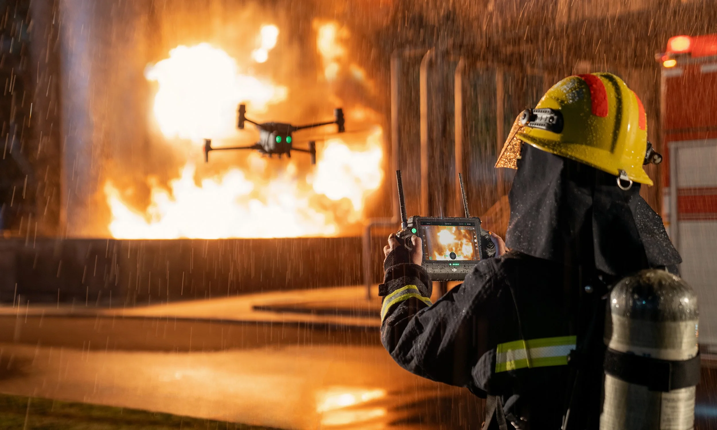
Accident Reconstruction Workflow with the Mavic 3 Enterprise
When road accidents occur, public safety personnel will often need to document the scene. This critical step, also known as accident reconstruction, is a delicate balancing act between accuracy and speed - every second the road remains obstructed means heavier traffic and increased safety risk for everyone involved.
Drones are a proven answer to help document scenes and keep personnel safe. sUAS mapping takes a fraction of the time of traditional or legacy scene documentation (e.g. total stations), resulting in quick clearance. Actual scenes are preserved in 3D with detailed information and centimeter accuracy.
Read More
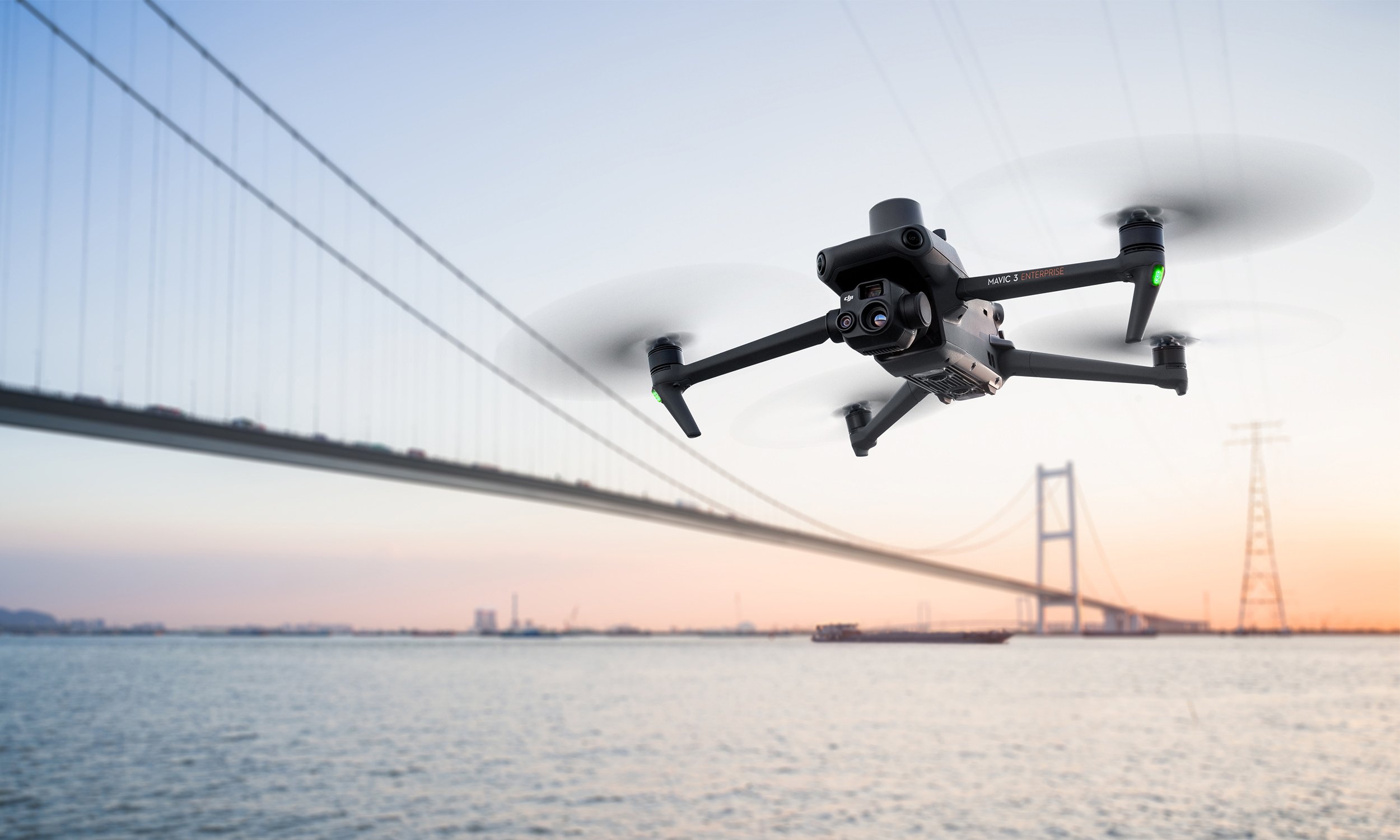
Top 7 Features of the Mavic 3 Enterprise Series
The Mavic 3E (M3E) is a compact, portable, and powerful drone for everyday operations. Whether you’re a hobbyist pilot ready to go pro or searching for a versatile platform to bolster your commercial fleet, the Mavic 3E sets a new industry benchmark.
The M3E’s features make it our most accessible and capable surveying drone to date, while a thermal version, Mavic 3T, is available for emergency, inspection, and night operations. Here are seven things that make the Mavic 3 Enterprise Series the ultimate portable and professional drone platform.
Read More
The New DJI Mavic 3 Enterprise Series Sets Ultimate Standard For Portable Commercial Drones
With A 56× Zoom Camera And RTK Module For Centimeter-Level Precision, The Mavic 3 Enterprise Series Brings Mission Efficiency To New Heights.
Read More
Comparing DJI's Thermal and Low Light Drones
Trying to choose a drone platform for low light or thermal ops? See how the Matrice 30T (M30T), Zenmuse H20N camera, and Mavic 2 Enterprise Advanced (M2EA) results look side by side
Read More
Why You Need A Pilot On Your Team
As more surveyors see the benefits of integrating drones into their projects, companies are now looking to train their team to take the controls themselves. Upskilling has never been easier with a breadth of new courses specifically designed to turn surveyors into competent and confident drone pilots.
Read More
Top 6 Features of the H20N
The DJI M300 has set the standard for enterprise drones with a combination of durability, performance, and advanced payloads. It was released in 2020 alongside the Zenmuse H20, a hybrid multi-sensor solution for industrial applications and public safety missions. The H20T, L1, and P1 followed soon after. Our latest payload, the H20N, is a hybrid thermal, zoom, laser rangefinder, and Starlight sensor that offers powerful aerial insights - no matter the weather or time of day.
Read More
Top 9 Features of the M30
For years DJI have been working closely with public safety teams and infrastructure inspection crews to take enterprise drone technology forward and integrate it into critical operations. The new DJI Matrice 30 is a case in point, with features inspired by the lessons DJI have learned from thousands of flight hours and feedback from pilots on the front lines.
The launch of the M30 once again pushes the boundaries of what’s possible. They have incorporated flagship features and performance into a foldable airframe you can fit inside a backpack.
From rapid deployment to compatibility with the new DJI Dock, here are nine things that make the M30 a groundbreaking drone for public safety and asset inspections.
Read More
Using Point Clouds
Whenever you need to create a detailed model of an area — for surveying, accident reconstruction, or any other purpose — creating a point cloud can be the best way to get the job done.
An accurate, detailed, high-resolution 3D point cloud model is an important element in accurate 3D model creation. If your organization is seeking a new way to create digital reconstructions of physical spaces or structures, drones capable of generating point clouds may be the perfect tool for you.
Read More
Making Orthomosaics With Drones: Everything You Need To Know
Drone surveying is a lot more complicated than snapping an aerial photograph or two and calling it a day. You need to be sure your images can be scaled properly with each other and aren’t distorted. On a job where being off by only a few inches can have a great impact on your work, getting it right matters.
Read More
Thermal Drone Applications
Thermal imaging in drones has been gaining popularity in recent years as this technology has become more accessible with significant price decreases in recent months.
In this article we are showcasing a selection of applications our customers in New Zealand have been using with thermal drones.
Read More
Working with Youth Search and Rescue to train the heroes of tomorrow
Ferntech is partnering with Youth Search and Rescue (YSAR) to sponsor volunteer leaders to undertake UAV training at Massey University. YSAR is an independent non-profit organisation which enables students — young men and women from 14–18 years old — to develop the necessary skills to become active members of community volunteer Search and Rescue and Emergency Management organisations.
Read More
Thermal Camera on Drones how do they work?
Remote aerial sensing technology gives inspection personnel, Search and Rescue and Law Enforcement agencies more thorough, frequent, safer, and efficient inspections. Drones equipped with infrared cameras can be used to detect irregularities in insulation and pooling water, find a missing person in dangerous terrain or assess a fire hazard situation. With a zoom camera drone, the pilots can visually identify problems without having to be physically there. Read more to find out about Thermal Imaging Drones.
Read More
Ferntech Brings DJI's Most Advanced Commercial Drone to New Zealand
We at Ferntech Commercial is excited to bring this technology to our shores in New Zealand. The DJI Matrice 300 RTK is an exceptional drone offering up to 55 minutes of flight time, advanced AI capabilities, 6 Directional Sensing & Positioning and more; the DJI Matrice 300 RTK sets a whole new standard by combining intelligence with high-performance and unrivalled reliability.
Read More
Mavic 2 Enterprise Now Supports ATTI Mode
The DJI Mavic 2 Enterprise and DJI Smart Controller receives a new firmware update that includes ATTI mode. This is a first in the DJI’s Mavic line up and will surely make New Zealand's commercial drone operators happy.
Read More
DJI Fighting Malaria with Drones
Malaria ranks amongst the world's deadliest diseases and has claimed over 52 billion lives. Although significant progress has been made to combat malaria with conventional techniques, more is needed to eliminate it completely. Deploying the cutting-edge Agras MG-1S drone, the DJI team partnered with the Zanzibar Malaria Elimination Programme (ZAMEP) and the local community in a novel project to reduce malaria transmission. Watch as they embark on a journey of innovation, using drones in a bid to curb this deadly disease.
Read More
Ferntech Commercial joins Search and Rescue training exercise
YSAR started UAV operations since 2017 when GPS-IT donated a Phantom drone to the team. Since then the three-year training programme included the subject focused on UAV/Drones in Search and Rescue and Civil Defence Emergency Management. On the 14th of December, the Ferntech Commercial team joined their training exercise bringing along the full fleet of drones for Search and Rescue operations.
Read More
DJI launches a gas detector and spotlight for the Matrice series
With it’s annual Airworks event in Los Angeles on the horizon, DJI have announced two new Enterprise payloads designed for the Matrice series. Powered by DJI Skyport, the U10 AUV Based Laser Methane Leakage Detector and the Wingsland Z15 Gimbal Spotlight have been designed with specific commercial applications in mind.
Read More
DJI creates high-security solution for government drone programs
The world leader in civilian drones and aerial imaging technology DJI is introducing DJI Government Edition, a new comprehensive drone solution created specifically for use in high-security situations by government agencies around the world.
Read More
DJI AirSense will be available to DJI Drones from 2020
Currently, AirSense is only installed to a number of DJI’s enterprise drones, such as the Mavic 2 Enterprise and the Matrice M200. This commitment from DJI sets a new standard by putting professional-grade aviation safety technology in drones available to everyone.
Read More